
Sanjida Suchi
Geospatial Researcher
Tools & Technologies
- • Sentinel-1 SAR
- • SNAP Software
- • Snaphu
- • ArcGIS Pro
Study Area
Location: Turkey-Syria Border
Event: 2023 Earthquake
Magnitude: 7.8
Radar Assignment: Displacement Analysis
Analysis of Ground Deformation from the 2023 Turkey-Syria Earthquake using SAR Interferometry
Project Overview
This project is a high-resolution ground displacement map of the 2023 Turkey–Syria earthquake using Sentinel-1 SAR imagery. Pre- and post-event images were processed in SNAP, including sub-swath extraction, orbit file correction, interferogram generation, topographic phase removal, multilooking, and Goldstein filtering, with phase unwrapping performed using Snaphu. The terrain-corrected displacement map highlights maximum ground movement (~-44 cm) near the earthquake epicenter, providing a clear visualization of seismic impacts. Through this workflow, I gained hands-on experience in SAR data processing, interferometric analysis, and geospatial visualization, while learning how topography and noise affect measurement accuracy. The study demonstrates the practical relevance of remote sensing for geohazard monitoring, offering insights for disaster assessment, risk mitigation, and rapid response planning in earthquake-affected regions.
Dataset Analysis
Pre-Event Data
- • Date: January 29, 2023
- • Source: Sentinel-1 SLC
- • Coverage: Earthquake epicenter
Post-Event Data
- • Date: February 10, 2023
- • Source: Sentinel-1 SLC
- • Coverage: Same footprint
Processing Workflow
Data Preparation
- • TOPS Split for sub-swath selection
- • Orbit file application
- • Back-geocoding for coregistration
Interferogram Generation
- • Phase interferogram creation
- • TOPS Deburst application
- • Goldstein phase filtering
Key Findings
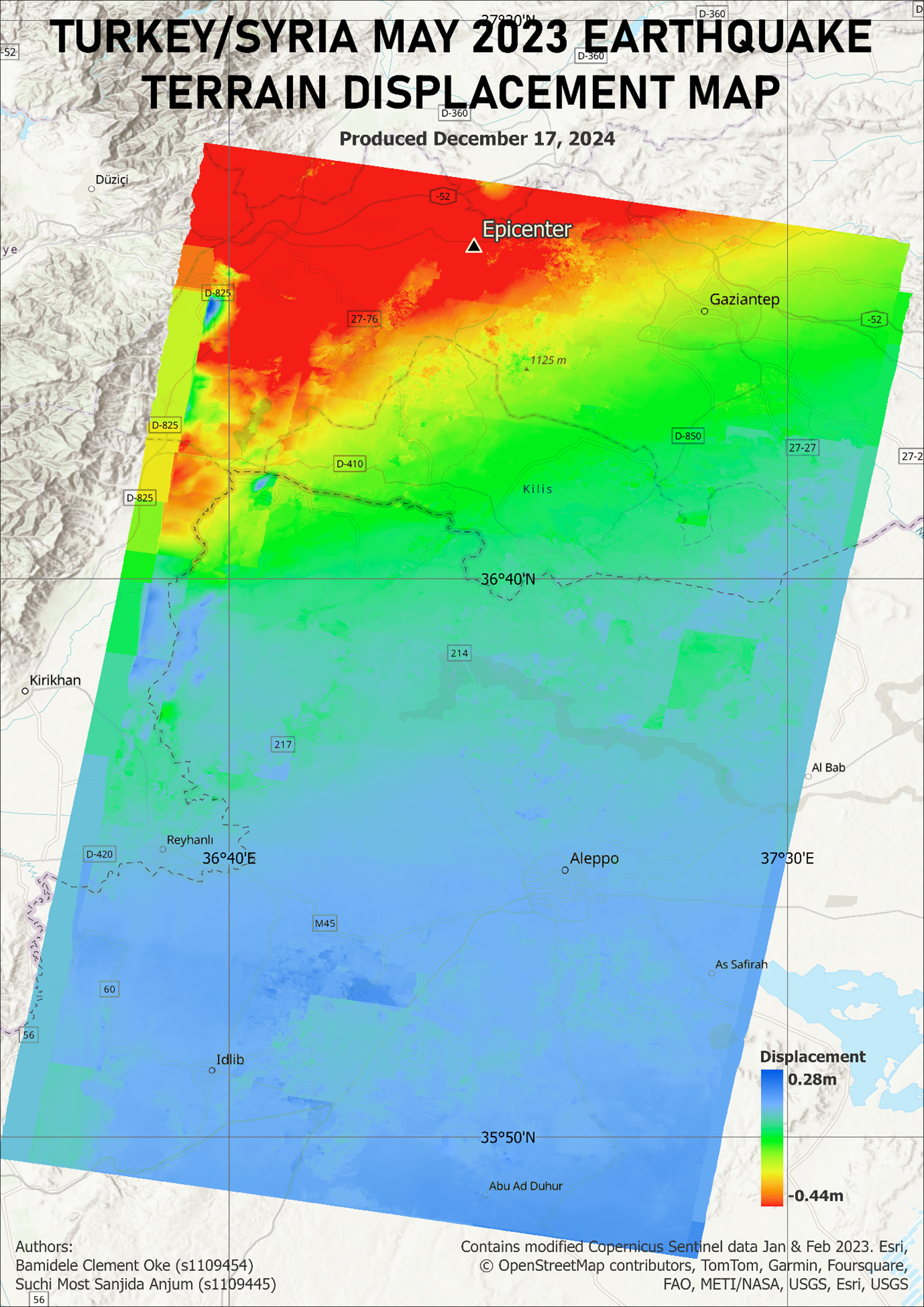
The displacement map revealed significant ground deformation with maximum downward displacement of approximately -44cm in areas near the earthquake epicenter. Multiple depression zones were identified, showing clear correlation with the seismic event's intensity and distribution.